Zapata County

Zapata County, Texas

Zapata County, Texas
Zapata County is on U.S. Highway 83 south of Laredo in the Rio Grande Plain region of South Texas. The county, named for local rancher Antonio Zapata, is bordered on the north by Webb County, on the east by Jim Hogg and Starr counties, and on the west by Mexico. The center of the county is at 26°58' north latitude and 99°10' west longitude. The county's largest town and county seat is Zapata, which is on the Rio Grande at the junction of U.S. Highway 83 and State Highway 16. Other communities include San Ygnacio, Ramireño, Escobas, Falcon, and Lopeño. Zapata County covers 999 square miles, with elevations from 200 to 700 feet above sea level. The county generally has light-colored loamy soils over reddish or mottled clayey subsoils; limestone lies in places within forty inches of the surface. The flora includes thorny shrubs, grasses, mesquite, and cacti. Less than 1 percent of the county is considered prime farmland. Natural resources include caliche, clay, lignite coal, sand, gravel, oil, and gas. Zapata County's climate is subtropical-subhumid. Temperatures range from an average of 44° F to 69° in January and 75° F to 100° in July. The average annual temperature is 74°. Rainfall averages nineteen inches a year, and the growing season lasts 295 days.
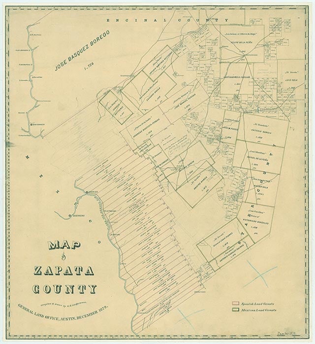
Artifacts dating from the Paleo-Indian period (9200 B.C. to 6000 B.C) demonstrate that humans have lived in the general area for perhaps 11,000 years. The local Indian population seems to have increased during the Archaic period (6000 B.C. to A.D. 1000), when many groups of hunter-gatherers spent part or all of their time in the region. The hunting and gathering life persisted into the Late Prehistoric period (A.D. 1000 to the arrival of the Spanish), though during this time Indians in the area learned to make pottery and hunted with bows and arrows. During historic times Zapata County was inhabited by Carrizos and Tepemaca Indians (Coahuiltecan groups) and Borrado Indians. The first European exploration of the region was probably made by Capt. Miguel de la Garza Falcón, who in 1747 led a group down the northern bank of the Rio Grande from the site of present day Eagle Pass to the mouth of the river following a route that later became known as the Old Military Highway. Garza described the land as "barren, with little or no water, scanty grass...and unfit for settlement for lack of an adequate water supply." Nevertheless, the first settlement in the future county was founded just three years later by José Vázquez Borrego, a rancher from Coahuila. On August 22, 1750, he founded Nuestra Señora de los Dolores Hacienda a few miles from the site of present San Ygnacio. To settle the area Vázquez moved twenty-three families from Coahuila. The same year, José de Escandón was in the area founding new settlements. Vázquez contacted Escandón and proposed that Dolores Hacienda be added to Escandón's list of proposed settlements. In exchange, Vázquez offered to establish a ferry on the river at his own expense. Escandón agreed, gave Vázquez the title of captain, and assigned him fifty sitios. After a visit to Dolores in early 1753, Escandón wrote to the viceroy commending Vázquez and his colonists and noting that the community was well established. Eventually Vázquez's holdings increased to 350,000 acres, and by 1755 the ferry at Dolores was the most important crossing on the Rio Grande. Originally, the southern part of the county was in the jurisdiction of Revilla, and both colonies were incorporated into Nuevo Santander. Colonists of Revilla, whose lands extended across the river, made a settlement at Carrizo (later Zapata) about 1770, which eventually became the area's largest settlement. Ranching was the primary industry in the early years. In 1757 Vázquez owned 5,000 horses and mules, 3,000 cattle, and more than 1,000 donkeys; he exported an estimated 500 mules per year. In 1818, after a series of Indian attacks, Hacienda Dolores was abandoned, though by 1830 it was once again occupied. In 1821 the future Zapata County, along with other settlements between the Nueces and the Rio Grande, became part of the Mexican state of Tamaulipas.
Alicia A. Garza, Christopher Long | © TSHA
Adapted from the official Handbook of Texas, a state encyclopedia developed by Texas State Historical Association (TSHA). It is an authoritative source of trusted historical records.
- ✅ Adoption Status:
- This place is available for adoption! Available for adoption!
- Adopted by:
- Your name goes here
- Dedication Message:
- Your message goes here
Currently Exists
Yes
Place type
Zapata County is classified as a County
Pronunciations
- zuh PAH tuh
Altitude Range
301 ft – 860 ft
Size
Land area does not include water surface area, whereas total area does
- Land Area: 998.4 mi²
- Total Area: 1,058.0 mi²
Temperature
January mean minimum:
46.3°F
July mean maximum:
97.8°F
Rainfall, 2019
19.8 inches
Population Count, 2019
14,179
Civilian Labor Count, 2019
4,784
Unemployment, 2019
13.5%
Property Values, 2019
$1,766,194,878 USD
Per-Capita Income, 2019
$28,294 USD
Retail Sales, 2019
$70,362,411 USD
Wages, 2019
$47,161,582 USD
County Map of Texas
Zapata County
- Zapata County
Places of Zapata County
| Place | Type | Population (Year/Source) | Currently Exists |
|---|---|---|---|
| Town | – | – | |
| Town | – | – | |
| Town | 10 (2009) | Yes | |
| Town | – | – | |
| Town | 73 (2019) | Yes | |
| Town | – | – | |
| Town | – | – | |
| Town | – | – | |
| Town | – | – | |
| Town | 2 (2009) | Yes | |
| Town | – | – | |
| Lake | – | Yes | |
| Town | 896 (2021) | Yes | |
| Town | 90 (2021) | Yes | |
| Town | – | – | |
| Town | – | – | |
| Town | – | – | |
| Town | – | – | |
| Town | – | – | |
| Town | 47 (2021) | Yes | |
| Town | 42 (2021) | Yes | |
| Town | 0 (2021) | Yes | |
| Town | 5,004 (2021) | Yes | |
| Town | 0 (2021) | Yes | |
| Town | 0 (2021) | Yes | |
| Town | – | – | |
| Town | – | – | |
| Town | 0 (2021) | Yes | |
| Town | – | – | |
| Town | – | – | |
| Town | – | – | |
| Town | 582 (2021) | Yes | |
| Town | – | – | |
| Town | 1,715 (2021) | Yes | |
| Town | – | – | |
| Town | 4,928 (2021) | Yes |
Proud to call Texas home?
Put your name on the town, county, or lake of your choice.
Search Places »