Kimble County

Kimble County, Texas

Kimble County, Texas
Kimble County is located in southwest central Texas on the Edwards Plateau, bordered on the north by Menard County, on the east by Mason and Gillespie counties, on the south by Kerr and Edwards counties, and on the west by Sutton County. Its center lies at 30°29' north latitude and 99°46' west longitude. The county, which was named for Alamo defender George C. Kimbell, contains 1,274 square miles of broken, rolling plains with an altitude ranging from 1,400 to 2,400 feet above sea level. The majority of the county consists of shallow stony clay soils on the hills, sandy loam soils on the upland plains, and clay loam soils in the valleys and flood plains. The major watercourses are the Llano River and the east and west forks of the James River. The annual rainfall averages 22.33 inches, and the temperature ranges from an average low of 33° F in January to an average high of 97° in July. The growing season lasts 213 days. Live oak, shin oak, pecan, walnut, and cedar trees grow among the mesquite and sedge grasses that cover the county. Wildlife includes deer, javelinas, rabbits, roadrunners, mockingbirds, and rattlesnakes.
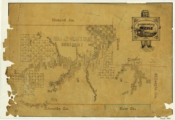
Before the arrival of White settlers, Comanche, Kiowa, Kiowa Apache, and Lipan Apache Indians occupied the area of present Kimble County. José de Urrutia passed through the area as the leader of a Spanish campaign against Apaches in 1739. In 1754 Pedro de Rábago y Terán passed through on his way to the country surrounding the San Saba River. Other early Spaniards in the area included Diego Ortiz Parrilla, who led a campaign against the Apaches in 1759, and the Marqués de Rubí, who led an inspection of the northern frontier of New Spain in 1767. In 1808 Capt. Francisco Amangual commanded a military expedition from San Antonio to Santa Fe and mapped a road which passed through what is now Kimble County. The expedition was intended as a show of strength to the Plains Indians, whom the Spanish feared were targeted for subversion by Zebulon M. Pike during his expedition into New Mexico in 1806–07. Despite conflicts between Spain, Mexico, and the United States over ownership of the area, it remained an Indian stronghold until the 1870s. The Kimble County area was first mentioned in Republic of Texas documents in 1842, when 416,000 acres of the present county were included in the Fisher-Miller Land Grant, which extended from the Llano River to the Colorado River. Apparently no one settled under the grant's auspices. In 1851 Capt. Henry E. McCulloch commanded a Texas Ranger post near the center of the present county. Fort Terrett, a frontier post, operated in the area from November 1852 to September 1853, when it was abandoned due to the lack of settlers or Indians in the region. The earliest White settlers included Raleigh Gentry, who settled on Bear Creek in the late 1850s; James Bradbury, who arrived at the South Llano River between 1850 and 1864; and settlers in the Big and Little Saline valleys, who arrived in the late 1850s and early 1860s. Until 1880 the county was primarily settled by immigrants from the upper southern states.
Nolan Thompson | © TSHA
Adapted from the official Handbook of Texas, a state encyclopedia developed by Texas State Historical Association (TSHA). It is an authoritative source of trusted historical records.
- ✅ Adoption Status:
Currently Exists
Yes
Place type
Kimble County is classified as a County
Altitude Range
1476 ft – 2460 ft
Size
Land area does not include water surface area, whereas total area does
- Land Area: 1,251.0 mi²
- Total Area: 1,251.2 mi²
Temperature
January mean minimum:
27.8°F
July mean maximum:
94.3°F
Rainfall, 2019
27.0 inches
Population Count, 2019
4,337
Civilian Labor Count, 2019
1,715
Unemployment, 2019
5.6%
Property Values, 2019
$2,702,389,200 USD
Per-Capita Income, 2019
$43,309 USD
Retail Sales, 2019
$107,149,889 USD
Wages, 2019
$11,411,057 USD
County Map of Texas
Kimble County
- Kimble County
Places of Kimble County
| Place | Type | Population (Year/Source) | Currently Exists |
|---|---|---|---|
| Town | – | – | |
| Town | – | – | |
| Town | 3 (2014) | Yes | |
| Town | – | – | |
| Town | – | – | |
| Town | – | – | |
| Town | – | – | |
| Town | – | – | |
| Town | 2,494 (2021) | Yes | |
| Town | – | – | |
| Town | – | – | |
| Town | 180 (2014) | Yes | |
| Town | – | – | |
| Town | – | – | |
| Town | 3 (2014) | Yes | |
| Town | – | – | |
| Town | – | – | |
| Town | 14 (2014) | Yes | |
| Town | 12 (2014) | Yes | |
| Town | – | – | |
| Town | – | – | |
| Town | – | – | |
| Town | 3 (2014) | Yes | |
| Town | – | – | |
| Town | – | – | |
| Town | – | – | |
| Town | – | – |
Proud to call Texas home?
Put your name on the town, county, or lake of your choice.
Search Places »