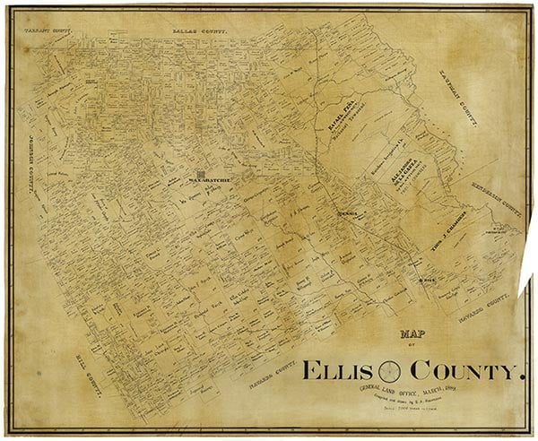
Ellis County

Ellis County, Texas

Ellis County, Texas
Ellis County is located in north central Texas. Waxahachie, the largest town and county seat, is on Interstate Highway 35E thirty miles south of Dallas. The county is bounded by Dallas County to the north, Kaufman to the east, Navarro and Hill counties to the south, and Johnson County to the west. The center point of the county is at 32°21' north latitude and 96°48' west longitude. Ellis County comprises 939 square miles of the Blackland Prairie. Away from the streams it is almost treeless except for scattered mesquite, cacti, and shrubs. Native vegetation consists mainly of bunch and short grasses, including Indian, buffalo, grama, big and little bluestems, and three-awn. Such native trees as ash, cottonwood, pecan, hackberry, bois d'arc, oak, and elm grow along watercourses. The terrain is level to rolling, with an elevation ranging from 300 to 700 feet above sea level. The area lies in a southeastward-sloping plain and is well drained by many streams that flow into the Trinity River, which forms the eastern boundary of the county. Red Oak, Waxahachie, Mill, and Chambers creeks drain most of the county. The Austin Escarpment, a high chalk ridge, extends in a northeast-southwest direction and cuts off drainage to the southeast. Mountain Creek flows northeast and drains the northwestern part of the county. The soils—predominantly calcareous, marly and variegated clays and clay loams—have average to good moisture retention and are underlain by a water supply sufficient for livestock, irrigation, and domestic purposes. The alluvial soils are mainly clay. Mineral resources include gas, oil, stone, and clays valuable for brickmaking. Chalk and shale provide material for the manufacture of cement. Temperatures range from an average low of 35° F in January to an average high of 96° in July, rainfall averages slightly less than thirty-six inches a year, and the growing season extends for 245 days.
Tonkawa Indians were the earliest inhabitants of the future county, though parties of Wacos, Bidais, Anadarkos, and Kickapoos often hunted in the area. Spanish missionaries worked with the Tonkawas, and as the American settlers began to move into the region in the middle of the nineteenth century, the Indians offered little organized resistance. By 1859 the Tonkawas had been removed to Oklahoma. Before the Texas Revolution in 1836, the Mexican government granted land in what is now Ellis County to Thomas J. Chambers, Rafael Peña, and Alejandro de la Garza. In 1841 and 1842 the Republic of Texas granted land to William S. Peters in the northern half of the county, and Charles Fenton Mercer received a grant in 1843 in the southern part. One of the first settlers in the area was William R. Howe, who settled late in 1843 near the site of present Forreston. Howe immigrated under the Peters colony project and reportedly brought in a Black woman thought to be the first slave in the county. The Southerland Mayfield family settled at Reagor Springs in February 1844, and the Billingsly family located near Ovilla later that year.
Robert J. Haaser | © TSHA
Adapted from the official Handbook of Texas, a state encyclopedia developed by Texas State Historical Association (TSHA). It is an authoritative source of trusted historical records.
- ✅ Adoption Status:
Currently Exists
Yes
Place type
Ellis County is classified as a County
Altitude Range
300 ft – 898 ft
Size
Land area does not include water surface area, whereas total area does
- Land Area: 935.5 mi²
- Total Area: 951.8 mi²
Temperature
January mean minimum:
33.8°F
July mean maximum:
93.9°F
Rainfall, 2019
39.1 inches
Population Count, 2019
184,826
Civilian Labor Count, 2019
91,416
Unemployment, 2019
7.1%
Property Values, 2019
$17,884,373,473 USD
Per-Capita Income, 2019
$44,313 USD
Retail Sales, 2019
$2,261,160,881 USD
Wages, 2019
$645,920,844 USD
County Map of Texas
Ellis County
- Ellis County
Places of Ellis County
| Place | Type | Population (Year/Source) | Currently Exists |
|---|---|---|---|
| Town | 392 (2021) | Yes | |
| Town | – | – | |
| Town | – | – | |
| Town | – | – | |
| Town | – | – | |
| Town | – | – | |
| Town | – | – | |
| Town | – | – | |
| Town | 400 (2009) | Yes | |
| Town | – | – | |
| Town | – | – | |
| Town | 637 (2021) | Yes | |
| Lake | – | Yes | |
| Town | – | – | |
| Town | – | – | |
| Town | 125 (2009) | Yes | |
| Town | – | – | |
| Town | – | – | |
| Town | 125 (2009) | Yes | |
| Town | 100 (2009) | Yes | |
| Town | 504 (2021) | Yes | |
| Town | – | – | |
| Town | – | – | |
| Town | – | – | |
| Town | – | – | |
| Town | – | – | |
| Town | 30 (2009) | Yes | |
| Town | – | – | |
| Town | 48,557 (2021) | Yes | |
| Town | – | – | |
| Town | – | – | |
| Town | – | – | |
| Town | – | – | |
| Town | – | – | |
| Town | – | – | |
| Town | – | – | |
| Town | 115 (2009) | Yes | |
| Town | – | – | |
| Town | – | – | |
| Town | 21,210 (2021) | Yes | |
| Town | – | – | |
| Town | – | – | |
| Town | – | – | |
| Town | 2,857 (2021) | Yes | |
| Town | 25 (2009) | Yes | |
| Town | 400 (2009) | Yes | |
| Town | – | – | |
| Town | 854 (2021) | Yes | |
| Town | – | – | |
| Town | – | – | |
| Town | – | – | |
| Town | 17,127 (2021) | Yes | |
| Town | – | – | |
| Town | – | – | |
| Town | 197,347 (2021) | Yes | |
| Town | – | – | |
| Town | – | – | |
| Town | – | – | |
| Town | – | – | |
| Town | – | – | |
| Town | – | – | |
| Town | – | – | |
| Town | – | – | |
| Town | – | – | |
| Town | – | – | |
| Town | 60 (2009) | Yes | |
| Town | – | – | |
| Town | – | – | |
| Town | 50 (2009) | Yes | |
| Town | 30 (2009) | Yes | |
| Town | 1,981 (2021) | Yes | |
| Lake | – | Yes | |
| Town | – | – | |
| Town | – | – | |
| Lake | – | Yes | |
| Town | – | – | |
| Town | – | – | |
| Town | – | – | |
| Town | – | – | |
| Town | – | – | |
| Town | 18 (2009) | Yes | |
| Town | – | – | |
| Town | – | – | |
| Town | – | – | |
| Town | – | – | |
| Town | – | – | |
| Town | 74,368 (2021) | Yes | |
| Town | – | – | |
| Town | 944 (2021) | Yes | |
| Town | – | – | |
| Town | 37,053 (2021) | Yes | |
| Town | 730 (2021) | Yes | |
| Town | – | – | |
| Town | 300 (2009) | Yes | |
| Town | 40 (2009) | Yes | |
| Town | – | – | |
| Town | – | – | |
| Town | – | – | |
| Town | – | – | |
| Town | – | – | |
| Town | – | – | |
| Town | 1,616 (2021) | Yes | |
| Town | – | – | |
| Town | – | – | |
| Town | – | – | |
| Town | – | – | |
| Town | 4,349 (2021) | Yes | |
| Town | – | – | |
| Town | 2,461 (2021) | Yes | |
| Town | – | – | |
| Town | 740 (2021) | Yes | |
| Town | – | – | |
| Town | – | – | |
| Town | 30 (2009) | Yes | |
| Town | – | – | |
| Town | – | – | |
| Town | 10 (2009) | Yes | |
| Town | – | – | |
| Town | 250 (2009) | Yes | |
| Town | – | – | |
| Town | 15,364 (2021) | Yes | |
| Town | – | – | |
| Town | 300 (2009) | Yes | |
| Town | – | – | |
| Town | – | – | |
| Town | 60 (2009) | Yes | |
| Town | – | – | |
| Town | – | – | |
| Town | – | – | |
| Town | – | – | |
| Town | – | – | |
| Town | – | – | |
| Town | – | – | |
| Town | – | – | |
| Town | 115 (2009) | Yes | |
| Town | – | – | |
| Town | – | – | |
| Town | – | – | |
| Town | 100 (2009) | Yes | |
| Town | – | – | |
| Town | – | – | |
| Town | 43,368 (2021) | Yes | |
| Town | – | – | |
| Town | – | – | |
| Town | – | – | |
| Town | – | – |
Photos Nearby:

Waxahachie, Texas
The Ellis County Courthouse in Waxahachie, the seat of Ellis County, Texas. Photograph by Renelibrary.
.jpg)

Midlothian, Texas
Midlothian, Texas Photo by Martin Ferreira from Pexels

Bardwell Dam was completed in 1965
Photo by U.S. Army Corps of Engineers, Public Domain

An aerial view of Joe Pool Lake and Dam
Photo by U.S. Army Corps of Engineers, Public Domain
Proud to call Texas home?
Put your name on the town, county, or lake of your choice.
Search Places »