Galveston County
, Galveston County, TX.jpg "City of Galveston, Galveston County, Texas")
.jpg)
City of Galveston, Galveston County, Texas

Galveston County, Texas
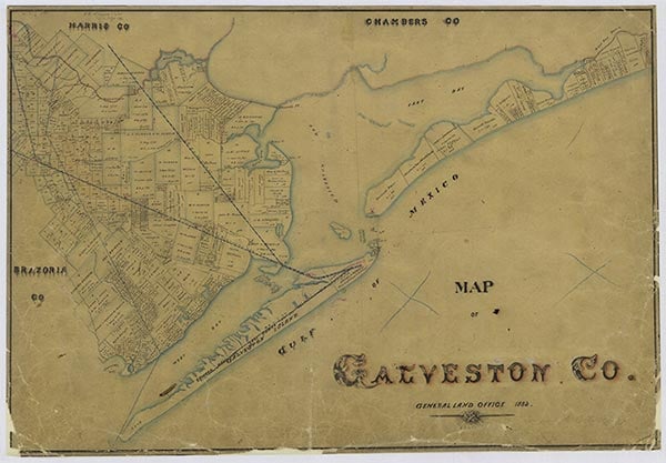
Galveston County is located on the Gulf Coast of Texas eighty miles southwest of the Louisiana state line, east of Brazoria County, and west of Chambers County; it is bounded by the Gulf of Mexico on the southeast. The county comprises mainland, Galveston Bay, and Galveston Island. The island, a slowly eroding bank of sand measuring three miles at its greatest breadth and twenty-eight miles at its greatest length, extends two miles southwest along the Gulf. Other barrier islands include Pelican Island, four miles out from Galveston, which was described in 1815 as a "narrow strip of marsh" and subsequently grew from shell deposits into an island four miles long and a half mile wide. Bolivar Peninsula is a slender strip of mainland northeast of Galveston Island and almost in line with it. Both Bolivar Peninsula and Galveston Island form natural storm barriers for Galveston Bay, which constitutes nearly half of the county's almost 450-square-mile area. The entrance to Galveston harbor, between Bolivar Point and Galveston Island, is about 1½ miles wide. Galveston, the county seat, is located at roughly the geographical center of the county (29°18' N, 94°47' W) on the Coastal Plain. Other towns in the county include Texas City, Port Bolivar, Clear Lake Shores, Crystal Beach, Jamaica Beach, Kemah, Hitchcock, Alta Loma, Dickinson, League City, La Marque, Algoa, Arcadia, and Friendswood. Altitudes in Galveston County range from a maximum height of thirty-five feet above sea level in the northwest sea level; the flat surface near the coast slopes gently to Galveston Bay and the Gulf of Mexico. The mainland coastline is indented with small bays, inlets, and marshes. Principal streams in Galveston County include Clear Creek, which forms the boundary between Galveston and Harris counties and empties into Clear Lake; Dickinson Bayou, which drains into Galveston Bay; and Highland Bayou, empties into Jones Bay and drains the western part of the county. Land in the area includes layered sand and clay and deep, sandy loams. The county has nearly 400 miles of beach. Many towns tap the Beaumont Clay, a water-bearing formation that underlies the county, for water supplies. The city of Galveston obtains its water from artesian wells. Drainage districts control flooding problems throughout the county. Grassland vegetation predominates, though live oak, water oak, magnolia, hackberry, and other trees grow along the creeks and bayous. The local water abounds with a variety of fish, including Spanish mackerel, red snapper, flounder, pompano, spotted sea trout, redfish, tarpon, oysters, and shrimp. The climate is humid, subtropical, and marine. Tropical disturbances in late summer and early fall are common. Hurricanes in 1900, 1915, 1961, and 1983 caused major damage, though construction of the Galveston seawall in 1902 lessened the effect of later storms. Rainfall averages 47.06 inches annually, and the growing season lasts for 320 days a year. The county's economy historically derives from its location as an important hub of land and sea transportation on the Gulf. Galveston is the oldest deepwater port west of New Orleans, and the community is noted for many "firsts" in Texas.
Evidence suggests that some Indian groups lived in the area as early as 10,000 B.P. and that exploitation of marine resources on the coastal margin occurred during the Late Prehistoric period. Bone-tempered pottery from this time has been excavated at campsites in the Galveston Bay area. An Atakapan burial ground roughly 5,000 years old was discovered near Caplen on Bolivar Peninsula, and flint artifacts were exhumed at the site. Archeologists have located shell middens begun some time after A.D. 100, and believe many other sites along the shore were damaged or destroyed by winds and tides. Numerous sites inland, small and showing few traces of pottery, suggest that early inhabitants pursued a mobile life style. The Karankawa Indians, a group of five nomadic, linguistically related groups including the Cocos, Cujanes, Karankawas proper, Coapites, and Copanos, later occupied the area from Galveston Bay to Corpus Christi Bay in late spring and summer. A Karankawa burial site was discovered at Jamaica Beach in 1962. Other Indian inhabitants included Coahuiltecans, Atakapan-related groups such as the Deadoses and Akokisas, small groups of Lipan Apaches and, in the 1770s, a Tonkawa group known as the Mayeyes. The Indian name for Galveston Island was Auia. Indian inhabitants began to leave when European settlers arrived, and most had retreated from the area by 1850.
Diana J. Kleiner | © TSHA
Adapted from the official Handbook of Texas, a state encyclopedia developed by Texas State Historical Association (TSHA). It is an authoritative source of trusted historical records.
- ✅ Adoption Status:
Currently Exists
Yes
Place type
Galveston County is classified as a County
Altitude Range
0 ft – 40 ft
Size
Land area does not include water surface area, whereas total area does
- Land Area: 378.4 mi²
- Total Area: 873.8 mi²
Temperature
January mean minimum:
48.6°F
July mean maximum:
89.6°F
Rainfall, 2019
50.8 inches
Population Count, 2019
342,139
Civilian Labor Count, 2019
163,153
Unemployment, 2019
9.7%
Property Values, 2019
$34,630,149,074 USD
Per-Capita Income, 2019
$51,785 USD
Retail Sales, 2019
$4,274,409,748 USD
Wages, 2019
$1,492,939,636 USD
County Map of Texas
Galveston County
- Galveston County
Places of Galveston County
| Place | Type | Population (Year/Source) | Currently Exists |
|---|---|---|---|
| Town | 135 (2009) | Yes | |
| Town | – | – | |
| Town | – | – | |
| Town | – | – | |
| Town | 10,567 (2021) | Yes | |
| Town | 1,755 (2021) | Yes | |
| Town | – | – | |
| Town | 2,829 (2021) | Yes | |
| Town | – | – | |
| Town | – | – | |
| Town | – | – | |
| Town | 60 (2014) | Yes | |
| Town | – | – | |
| Town | 1,263 (2021) | Yes | |
| Town | – | – | |
| Town | 800 (2009) | Yes | |
| Town | 21,697 (2021) | Yes | |
| Town | – | – | |
| Town | – | – | |
| Town | – | – | |
| Town | – | – | |
| Town | – | – | |
| Town | – | – | |
| Town | 41,004 (2021) | Yes | |
| Town | – | – | |
| Town | 53,219 (2021) | Yes | |
| Town | 300 (2014) | Yes | |
| Town | – | – | |
| Town | – | – | |
| Town | – | – | |
| Town | 300 (2014) | Yes | |
| Town | – | – | |
| Town | – | – | |
| Town | 7,408 (2021) | Yes | |
| Town | – | – | |
| Town | – | – | |
| Town | – | – | |
| Town | – | – | |
| Town | 1,072 (2021) | Yes | |
| Town | 1,803 (2021) | Yes | |
| Town | – | – | |
| Town | 18,697 (2021) | Yes | |
| Town | – | – | |
| Town | 115,595 (2021) | Yes | |
| Town | – | – | |
| Town | – | – | |
| Town | – | – | |
| Town | – | – | |
| Town | – | – | |
| Town | – | – | |
| Town | – | – | |
| Town | 700 (2009) | Yes | |
| Town | – | – | |
| Town | 5,144 (2021) | Yes | |
| Town | 12,783 (2021) | Yes | |
| Town | – | – | |
| Town | – | – | |
| Town | – | – | |
| Town | – | – | |
| Town | – | – | |
| Town | – | – | |
| Town | 54,247 (2021) | Yes | |
| Town | 1,103 (2021) | Yes | |
| Town | – | – |
Photos Nearby:

Galveston, Texas
Galveston, Texas Photo by Paul Silva on Unsplash

The Bacliff Fire Department
The Baycliff volunteer fire department on Grand Avenue. Photo by WhisperToMe (Public Domain)
Proud to call Texas home?
Put your name on the town, county, or lake of your choice.
Search Places »