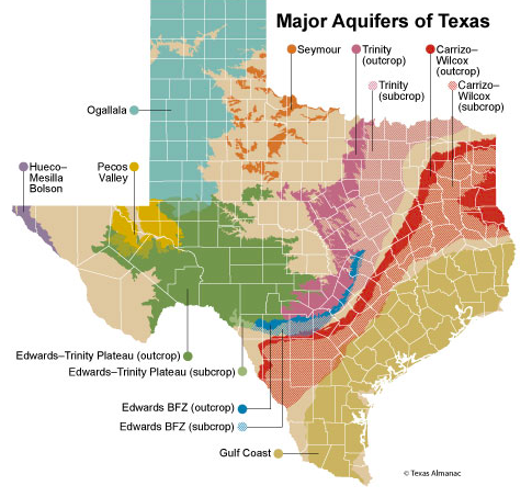
Historically, Texas has had a wealth of fresh to slightly saline water, which underlies more than 81 percent of the state. About 60 percent of the approximately 16 million acre-feet of water used yearly in Texas is derived from underground formations that make up 9 major and 22 minor aquifers (for map of minor aquifers, click).
Nearly 80 percent of the groundwater produced in 2008 was used for irrigating crops, especially in the Panhandle region. Groundwater also supplies about 35 percent of the state’s municipal needs.
Major Aquifers of Texas
Ogallala
The Ogallala aquifer extends through 48 counties of the Texas Panhandle and is the southernmost extension of the largest aquifer (High Plains aquifer) in North America. The Ogallala Formation of late Miocene to early Pliocene age consists of heterogeneous sequen-ces of coarse-grained sand and gravel in the lower part, grading upward into clay, silt, and fine sand. In Texas, the Panhandle is the most extensive region irrigated with groundwater. In 2008, almost 96 percent of the water pumped from the Ogallala was used for irrigation.
Water-level declines are occurring in part of the region because of extensive pumping that far exceeds recharge. Water-conservation measures by agricultural and municipal users are being promoted. Computer models of the northern and southern portions of the Ogallala aquifer were completed by the Texas Water Development Board and its contractor. Several agencies are investigating playa recharge and agricultural re-use projects over the aquifer.
Gulf Coast Aquifer
The Gulf Coast aquifer forms an irregularly shaped belt that parallels the Texas coastline and extends through 54 counties from the Rio Grande northeastward to the Louisiana border. The aquifer system is composed of the Catahoula, Oakville, Fleming, Goliad, Willis, Lissie, Bentley, Montgomery, and Beaumont formations.
This system has been divided into three major water-producing components referred to as the Chicot, Evangeline, and Jasper aquifers. In 2008, municipal uses accounted for 62 percent and irrigation accounted for 25 percent of the total pumpage from the aquifer.
Water quality is generally good northeast of the San Antonio River basin, but deteriorates to the southwest. Years of heavy pumpage have caused significant water-level declines in portions of the aquifer. Some of these declines have resulted in significant land-surface subsidence, particularly in the Houston-Galveston area.
Edwards (Balcones Fault Zone)
The Edwards (BFZ) aquifer forms a narrow belt extending through 13 counties from a groundwater divide in Kinney County through the San Antonio area northeastward to the Leon River in Bell County. A poorly defined groundwater divide in Hays County hydrologically separates the aquifer into the San Antonio and Austin regions. Water in the aquifer occurs in fractures, honeycomb zones (or intergranular pores), and solution channels in the Edwards and associated limestone formations of Cretaceous age.
In 2008, about 72 percent of pumpage from the aquifer was for municipal use. Irrigation was the principal use in Medina and Uvalde counties. Until recently, San Antonio was one of the largest cities in the world that relied solely on a single groundwater source for its municipal supply. The aquifer now provides approximately 90 percent of the city’s drinking water. The aquifer also feeds several well-known recreational springs and underlies some of Texas’ most environmentally sensitive areas.
In 1993, the Edwards Aquifer Authority (EAA) was created by the legislature to regulate aquifer pumpage to benefit all users from Uvalde County through a portion of Hays County. Barton Springs–Edwards Aquifer Conservation District provides aquifer management for the rest of Hays and southern Travis counties, and the Kinney County Groundwater Conservation District manages the aquifer segment within Kinney County.
The EAA has an active program to educate the public on water conservation and also operates several active groundwater recharge sites. The San Antonio River Authority also has a number of flood-control structures that effectively recharge the aquifer.
Conservation districts are promoting more-efficient irrigation techniques, and market-based, voluntary transfers of unused agricultural water rights to municipal uses are more common.
Carrizo-Wilcox
Extending from the Rio Grande in South Texas northeastward into Arkansas and Louisiana, the Carrizo-Wilcox aquifer provides water to all or parts of 66 counties. The Wilcox Group and overlying Carrizo Sand form a hydrologically connected system of sand locally interbedded with clay, silt, lignite, and gravel.
Throughout most of its extent in Texas, the aquifer yields fresh to slightly saline water that is used mainly for irrigation in the Winter Garden District of South Texas, and for public supply and industrial use in Central and Northeast Texas. In 2008, irrigation accounted for 43 percent of water pumped from the aquifer, and municipal supply accounted for 47 percent.
Excessive pumping has lowered the water level, particularly in the artesian portion of the Winter Garden District of Atascosa, Dimmit, Frio, LaSalle, and Zavala counties and in the municipal and industrial areas of Angelina, Nacogdoches, and Smith counties.
Trinity
The Trinity Aquifer consists of basal Cretaceous-age Trinity Group formations extending through 61 counties from the Red River in North Texas to the Hill Country of Central Texas. The aquifer is comprised of the Twin Mountains, Glen Rose, Paluxy, Hosston, and Hensell formations. Where the Glen Rose thins or is absent, the Twin Mountains and Paluxy formations coalesce to form the Antlers Formation. In the south, the Trinity includes the Glen Rose and underlying Travis Peak formations. Water from the Antlers portion is used mainly for irrigation in the outcrop area of North and Central Texas.
Elsewhere, water from the Trinity Aquifer is used primarily for municipal and domestic supply. Municipal use accounted for 63 percent of the total aquifer use in 2008. Extensive development of the Trinity Aquifer in the Dallas-Fort Worth and Waco areas has resulted in water-level declines of 350 to more than 1,000 feet.
Edwards-Trinity Plateau
This aquifer underlies the Edwards Plateau, extending through 40 counties from the Hill Country of Central Texas westward to the Trans-Pecos region. It consists of sandstone and limestone formations of the Trinity formations, and limestones and dolomites of the Edwards and associated limestone formations. Groundwater movement is generally toward the southeast.
Near the plateau’s edge, flow is toward the main streams, where the water issues from springs. Irrigation, mainly in the northwestern portion of the region, accounted for about 79 percent of total aquifer use in 2008 and has resulted in significant water-level declines in Glasscock and Reagan counties. Elsewhere, the aquifer supplies fresh but hard water for municipal, domestic, and livestock use.
Seymour
This aquifer consists of isolated areas of alluvium found in parts of 25 north-central and Panhandle counties in the upper Red River and Brazos River basins. Eastward-flowing streams during the Quaternary Period deposited discontinuous beds of poorly sorted gravel, sand, silt, and clay that were later dissected by erosion, resulting in the isolated remnants of the formation. Individual accumulations vary greatly in thickness, but most of the Seymour is less than 100 feet.
The lower, more permeable part of the aquifer produces the greatest amount of groundwater. Irrigation pumpage accounted for 94 percent of the total use from the aquifer in 2008. Water quality generally ranges from fresh to slightly saline. However, the salinity has increased in many heavily pumped areas to the point where the water has become unsuitable for domestic and municipal use. Natural salt pollution in the upper reaches of the Red and Brazos river basins precludes the full utilization of these water resources.
Hueco-Mesilla Bolson
These aquifers are located in El Paso and Hudspeth counties in far West Texas and occur in Tertiary and Quaternary basin-fill deposits that extend northward into New Mexico and westward into Mexico. The Hueco Bolson, located on the eastern side of the Franklin Mountains, consists of up to 9,000 feet of clay, silt, sand, and gravel and is an important source of drinking water for both El Paso and Juarez, Mexico.
Located west of the Franklin Mountains, the Mesilla Bolson reaches up to 2,000 feet in thickness and contains three separate water-producing zones.
Historical large-scale groundwater withdrawals, especially for the municipal uses of El Paso and Juarez, have caused major water-level declines and significantly changed the direction of flow, causing a deterioration of the chemical quality of the groundwater in the aquifer, according to El Paso Water Utilities and the USGS.
Municpal water use in 2008 accounted for 87 percent of total use from the Hueco-Mesilla Bolson. El Paso, however, has reduced its use of groundwater from the Hueco Bolson since 1989, and observation wells indicate that water levels have stabilized. El Paso and Fort Bliss also have built the world’s largest inland desalination plant in El Paso County, which uses brackish groundwater from the Hueco Bolson.
Pecos Valley
Located in the upper Pecos River Valley of West Texas, this aquifer, formerly called the Cenozoic Pecos Alluvium, extends through 12 counties. In 2008, 72 percent of groundwater pumped from the aquifer was used for irrigation, and the rest is withdrawn for industrial uses, power supply, and municipal use. Consisting of up to 1,500 feet of alluvial fill, the aquifer occupies two hydrologically separate basins: the Pecos Trough in the west and the Monument Draw Trough in the east.
Water is generally hard and contains dissolved-solids concentrations ranging from less than 300 to more than 5,000 parts per million. Water-level declines in excess of 200 feet have occurred in Reeves and Pecos counties but have slowed since the mid-1970s with the decrease in irrigation pumpage. Declines continue in Ward County due to increased municipal and industrial pumping.


