Guadalupe County

Guadalupe County, Texas

Guadalupe County, Texas
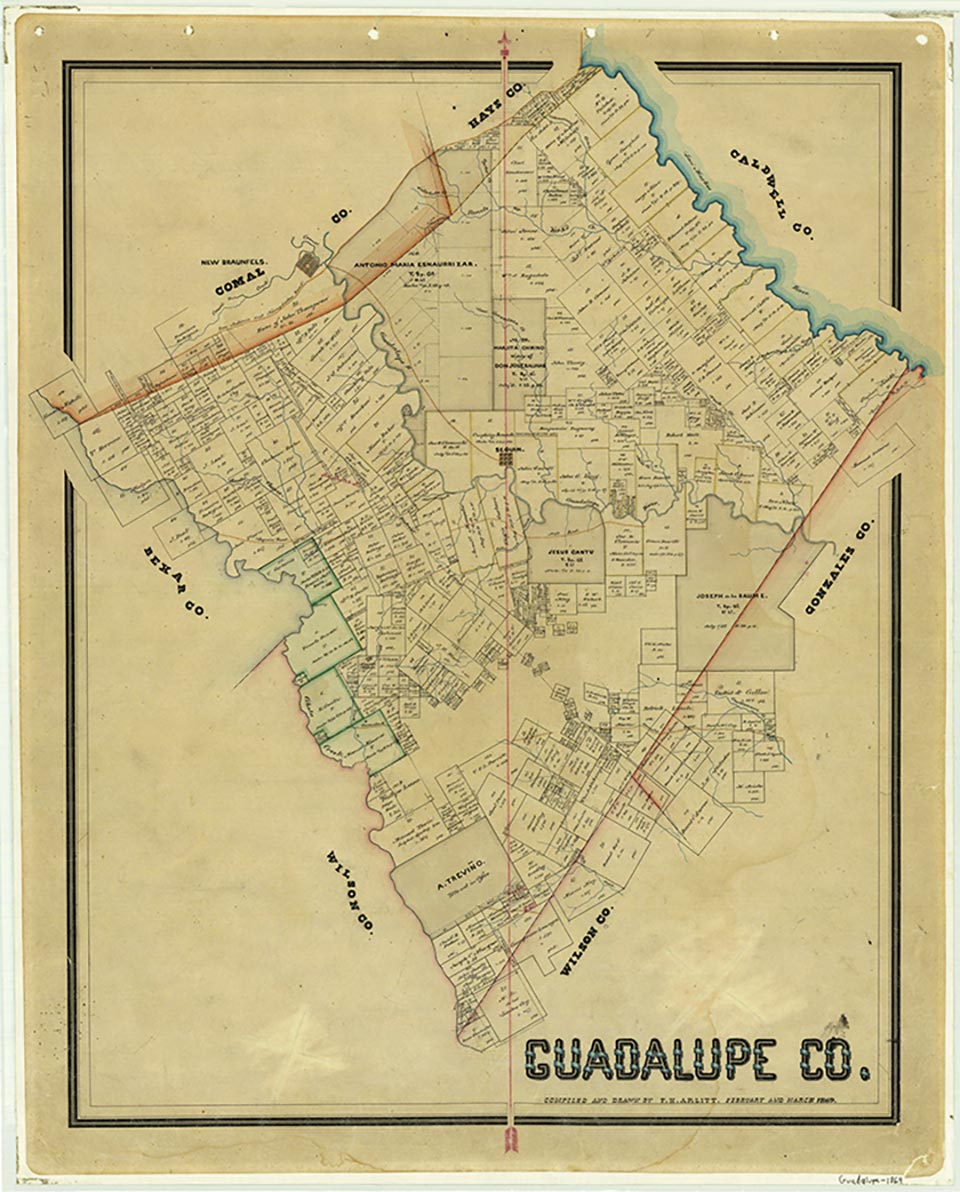
Guadalupe County is ninety miles inland from the Gulf of Mexico in south central Texas and is bounded by Comal, Hays, Caldwell, Gonzales, Wilson, and Bexar counties. Cibolo Creek forms the border between Guadalupe and Bexar counties, and the San Marcos River separates Guadalupe and Caldwell counties. Seguin, the county seat and largest town, is on Interstate Highway 10 and U.S. Highway 90, twenty-five miles southwest of Austin and eighteen miles northeast of San Antonio. The county's center lies near Seguin at approximately 29°35' north latitude and 97°57' west longitude. The county covers 713 square miles of flat to rolling terrain with local depressions and escarpments, and its elevation ranges from 450 to 800 feet above sea level. The northwestern section, near the border with Comal and Hays counties, is part of the Blackland Prairie; the rest of the county lies in the Upper Coastal Plain. Soil types vary from dark, calcareous clay in the northwest to fine, sandy loam in the southeast. Vegetation consists primarily of mesquite, scrub brush, and grasses in drier areas of the county, while water-tolerant hardwoods and conifers flourish near creeks. The area has a mild subtropical climate, with temperatures ranging from an average high of 96° in July and an average low of 42° in January. The annual rainfall in the county averages 33 inches, and the growing season averages 275 days.
The central Texas region, including Guadalupe County, has supported human habitation for several thousand years. Archaeologists believe some of the artifacts found in the area to be from the Archaic Period (ca. 5000 B.C. to 500 A.D.); other pieces are more recent, dating from 1200 to 1500. Indian tribes in the area included the Karankawas, Tonkawas, Comanches, and Lipan Apaches. Hostilities with Indians who camped along the Guadalupe River in the mid-1830s caused many of the early settlers to retreat from their land to Gonzales until more protection could be provided. After the Texas Revolution, the Tonkawas and the Lipan Apaches were friendly toward settlers and often traded with them, but the threat of raids by the Comanches remained until the 1843 council at Bird's Fort. After the Mexican War in 1848, federal troops established a line of forts extending from Fort Worth to Eagle Pass, effectively moving the frontier and the Indians well to the northwest of Guadalupe County. The last Indian raid into the area was made by the Kickapoos in 1855. The Spanish were probably the first Europeans to explore central Texas. Some sources suggest that Álvar Nuñez Cabeza de Vaca came through this part of central Texas in 1534, but others indicate that his route was farther south. Guadalupe County takes its name from the Guadalupe River, which Alonso de Leon named in 1689 in honor of the Lady of Guadalupe depicted on his standard. The Spanish government made one of the first land grants in the Guadalupe County area to José de la Baume in 1806 for land in the Capote Hills. He had to confirm his claim with the new government after Mexico won its independence from Spain and did not receive clear title until 1832. Between 1827 and 1835 twenty-two families came to the area as part of DeWitt's colony, and fourteen received grants directly from the Mexican government. Most of the settlers during this early period came from the southern United States. Many had land in the eastern part of the region along what came to be called Nash, Darst, and Mill creeks. These early settlers scarcely had time to form even the beginnings of communities before the combination of Indian raids and the Runaway Scrape forced them to retreat to Gonzales.
Vivian Elizabeth Smyrl | © TSHA
Adapted from the official Handbook of Texas, a state encyclopedia developed by Texas State Historical Association (TSHA). It is an authoritative source of trusted historical records.
- ✅ Adoption Status:
Currently Exists
Yes
Place type
Guadalupe County is classified as a County
Altitude Range
350 ft – 952 ft
Size
Land area does not include water surface area, whereas total area does
- Land Area: 711.3 mi²
- Total Area: 714.8 mi²
Temperature
January mean minimum:
40.5°F
July mean maximum:
95.2°F
Rainfall, 2019
34.6 inches
Population Count, 2019
166,847
Civilian Labor Count, 2019
79,827
Unemployment, 2019
7.1%
Property Values, 2019
$17,376,826,616 USD
Per-Capita Income, 2019
$44,809 USD
Retail Sales, 2019
$1,884,276,553 USD
Wages, 2019
$503,263,021 USD
County Map of Texas
Guadalupe County
- Guadalupe County
Places of Guadalupe County
| Place | Type | Population (Year/Source) | Currently Exists |
|---|---|---|---|
| Town | – | – | |
| Town | – | – | |
| Town | 46 (2009) | Yes | |
| Town | – | – | |
| Town | – | – | |
| Town | – | – | |
| Town | – | – | |
| Town | – | – | |
| Town | – | – | |
| Town | – | – | |
| Town | – | – | |
| Town | – | – | |
| Town | – | – | |
| Town | – | – | |
| Town | – | – | |
| Town | – | – | |
| Town | 33,475 (2021) | Yes | |
| Town | – | – | |
| Town | – | – | |
| Town | – | – | |
| Town | – | – | |
| Town | – | – | |
| Town | – | – | |
| Town | – | – | |
| Town | – | – | |
| Town | 88 (2009) | Yes | |
| Town | – | – | |
| Town | – | – | |
| Town | – | – | |
| Town | – | – | |
| Town | – | – | |
| Town | – | – | |
| Town | – | – | |
| Town | 984 (2021) | Yes | |
| Town | – | – | |
| Town | – | – | |
| Town | – | – | |
| Town | – | – | |
| Town | – | – | |
| Town | – | – | |
| Town | – | – | |
| Town | – | – | |
| Town | 95 (2009) | Yes | |
| Town | – | – | |
| Town | 134 (2021) | Yes | |
| Town | 1,412 (2021) | Yes | |
| Lake | – | Yes | |
| Lake | – | Yes | |
| Town | – | – | |
| Town | – | – | |
| Town | – | – | |
| Town | – | – | |
| Town | – | – | |
| Town | – | – | |
| Town | – | – | |
| Town | 1,044 (2021) | Yes | |
| Town | – | – | |
| Town | 2,536 (2021) | Yes | |
| Town | – | – | |
| Town | – | – | |
| Town | – | – | |
| Town | – | – | |
| Town | 679 (2021) | Yes | |
| Town | 98,857 (2021) | Yes | |
| Town | – | – | |
| Town | – | – | |
| Town | – | – | |
| Town | – | – | |
| Town | 65 (2009) | Yes | |
| Town | – | – | |
| Town | – | – | |
| Town | – | – | |
| Town | – | – | |
| Town | 3,353 (2021) | Yes | |
| Town | 68,580 (2021) | Yes | |
| Town | – | – | |
| Town | 771 (2021) | Yes | |
| Town | – | – | |
| Town | 42,622 (2021) | Yes | |
| Town | – | – | |
| Town | 678 (2009) | Yes | |
| Town | 30,902 (2021) | Yes | |
| Town | 11,619 (2021) | Yes | |
| Town | – | – | |
| Town | 188 (2021) | Yes | |
| Town | – | – | |
| Town | 294 (2009) | Yes | |
| Town | – | – | |
| Town | – | – | |
| Town | – | – | |
| Town | – | – | |
| Town | 172 (2009) | Yes | |
| Town | – | – | |
| Town | – | – | |
| Town | – | – | |
| Town | – | – | |
| Town | – | – | |
| Town | – | – | |
| Town | – | – | |
| Town | 595 (2009) | Yes | |
| Town | – | – | |
| Town | 287 (2009) | Yes | |
| Town | 375 (2021) | Yes |
Photos Nearby:

Kingsbury, Guadalupe County, Texas
Fire Station Building in the City of Kingsbury located in Guadalupe County, Texas. Photograph by Larry D. Moore.


San Marcos, Texas
The historic district in dowtown San Marcos, the seat of Hays County. Photograph by Larry D. Moore.

City of Marion, Guadalupe County, Texas
Marion Main Library, Guadalupe County, Texas. Photograph by Darrylpearson.

Staples, Guadalupe County, Texas
City of Staples located in Guadalupe County, Texas. Photograph by Darrylpearson.
.jpg)

New Berlin, Guadalupe County, Texas
City of New Berlin in Guadalupe County, Texas. Photograph by Darrylpearson.
.jpg)

City of Seguin, Texas
Guadalupe County Courthouse in the City of Seguin, the seat of Guadalupe County in Texas. Photograph by Billy Hathorn.

Geronimo, Texas
Geronimo, Texas Photo by Brandon Frie on Unsplash

A Quiet Day on Lake McQueeney
Lake McQueeney is popular for boating, swimming, and fishing. Photo by Larry D. Moore, CC By SA 4.0
Proud to call Texas home?
Put your name on the town, county, or lake of your choice.
Search Places »